Sequence image 03. Maxar AFTER I.R. Satellite imagery of homes destroyed in Pacific Palisades, Los Angeles, California. Note: Red indicates healthy...加州, 洛杉磯市, 從衛星觀看
Sequence image 08. AFTER Maxar satellite imagery of La Costa Beach, Malibu, Los Angeles, California following the devestating fires. Please use:...洛杉磯市, 衛星 - 太空旅行器, 加州
Sequence image 11. Maxar BEFORE satellite image of homes and a neighborhood along Alltadena Drive in Altadena, California. Please use: Satellite...從衛星觀看, 衛星 - 太空旅行器, 加州
Sequence image 08. Maxar AFTER satellite image of the homes and businesses along PCH, Tuna Canyon, Palisades, California. Please use: Satellite image...衛星 - 太空旅行器, 從衛星觀看, 加州
Sequence image 12. Maxar DURING satellite image of homes and a neighborhood on fire along Alltadena Drive in Altadena, California. Please use:...從衛星觀看, 衛星 - 太空旅行器, 加州
Sequence image 09. Maxar BEFORE satellite image of homes and an entire neighborhood near Fair Oaks Avenue in Altadena, California. Please use:...衛星 - 太空旅行器, 從衛星觀看, 加州
Sequence image 14. Maxar AFTER satellite image of homes and a neighborhood totally destroyed in Altadena, California. Please use: Satellite image...從衛星觀看, 衛星 - 太空旅行器, 加州
Sequence image 07. Maxar BEFORE satellite image of the homes and businesses along PCH, Tuna Canyon, Palisades, California. Please use: Satellite...從衛星觀看, 衛星 - 太空旅行器, 加州
Sequence image 03. Maxar short wave infrared blended satellite imagery of the Summit Pacific Palisades fire. Please use: Satellite image 2025 Maxar...衛星 - 太空旅行器
Sequence image 13. Maxar BEFORE satellite image of homes and a neighborhood in Altadena, California. Please use: Satellite image 2025 Maxar...衛星 - 太空旅行器, 從衛星觀看, 加州
Sequence image 10. Maxar DURING satellite image of homes and an entire neighborhood on fire near Fair Oaks Avenue in Altadena, California. Please...從衛星觀看, 加州, 森林大火
Maxar satellite imagery of Mischief Reef in the South China Sea, a part of the Spratly Islands group, being built by Chinese dredges. Please use:...Mischief Reef, 南沙群島, 衛星 - 太空旅行器
Maxar satellite imagery of the Fiery Cross Reef in the South China Sea, a part of the Spratly Islands group, being built by Chinese dredges. Please...南沙群島, 南中國海, Fiery Cross Reef
This June 9th image shows the Jinggangshan, the second Yuzhao-class Assault Ship , dead-in-the-water off Woody Island. The Jinggangshan carries air...中國
This is a satellite image of the controversial construction of a helipad, buildings, and wharfs on the Subi Reef in China, collected on August 8,...Subi Reef
Maxar satellite imagery of the Fiery Cross Reef in the South China Sea, a part of the Spratly Islands group. Please use: Satellite Image 2022 Maxar...Fiery Cross Reef
Maxar satellite imagery of the Fiery Cross Reef in the South China Sea, a part of the Spratly Islands group. Please use: Satellite Image 2022 Maxar...Fiery Cross Reef
Maxar satellite imagery of the Fiery Cross Reef in the South China Sea, a part of the Spratly Islands group. Please use: Satellite Image 2022 Maxar...Fiery Cross Reef, 南沙群島, 衛星 - 太空旅行器
Maxar satellite imagery of the Fiery Cross Reef in the South China Sea, a part of the Spratly Islands group. Please use: Satellite Image 2022 Maxar...Fiery Cross Reef, 南沙群島, 衛星 - 太空旅行器
Maxar satellite imagery of the Mischief Reef in the South China Sea, a part of the Spratly Islands group. Please use: Satellite Image 2022 Maxar...Mischief Reef
Maxar satellite imagery of the Mischief Reef in the South China Sea, a part of the Spratly Islands group. Please use: Satellite Image 2022 Maxar...Mischief Reef
Maxar overview after satellite imagery of the damage cause by the tsunami. Satellite image 2021 Maxar Technologies.海嘯
Maxar high-resolution before satellite imagery of the damage cause by the tsunami. Satellite image 2021 Maxar Technologies.海嘯
An overview of the construction area related to the future underground centrifuge assembly facility in the mountainous area south of the Natanz...伊朗, 衛星 - 太空旅行器, 建築業
Maxar "after" satellite imagery of the damage path of the EF-5 tornado that hit Joplin on May 22, 2011. Please use: Satellite image 2019 Maxar...龍捲風, 影像, 衛星 - 太空旅行器
Maxar "before" satellite imagery of the damage path of the EF-5 tornado that hit Joplin on May 22, 2011. Please use: Satellite image 2019 Maxar...龍捲風
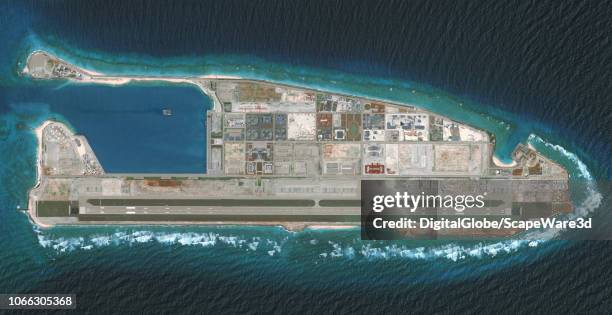
DigitalGlobe via Getty Images overview imagery of the Fiery Cross Reef located in the South China Sea. Fiery Cross is located in the western part of...Fiery Cross Reef, 南中國海, 從衛星觀看
DigitalGlobe via Getty Images imagery of the the west coast of Sumatra near the capital of Aceh, Banda Aceh. It was completely destroyed by the...
Figure 6a. Overview of Main Administrative Area on May 15, prior to removal of several buildings and significant landscaping effort.
Vantor satellite imagery shows an overview of a tunnel complex carved into rocky terrain near a developed facility area in Esfahan, Iran. The image...建築物, 伊朗, 從衛星觀看
Guangfu, Taiwan -SEQ 08 -- Maxar close-up satellite imagery reveals a destroyed section of Highway 9 bridge spanning a riverbed obscured by mud and...從衛星觀看, 緊急事故和災難, 水災
Maxar satellite imagery shows a damaged Choe Hyon-class destroyer docked at the Rajin repair facility following its recovery from a failed launch at...北韓, 驅逐艦
Maxar overview satellite imagery shows Mount Lico, an isolated granite mountain in northern Mozambique. Mount Lico is famous for its ancient...
Maxar imagery provides a detailed view of Tu-22 aircraft destroyed during a drone attack. The aircraft show clear signs of explosive damage. Please...俄羅斯, 空中交通工具, 影像
Sequence image 09. Maxar BEFORE satellite imagery of additional homes before the destruction in Pacific Palisades, Los Angeles, California. Please...衛星 - 太空旅行器, 洛杉磯市
Sequence image 10. Maxar AFTER satellite imagery of additional homes of the destruction in Pacific Palisades, Los Angeles, California. Please use:...衛星 - 太空旅行器, 洛杉磯市
Maxar satellite imagery of Tupras Stadium in Istambul, Turkey. Please use: Satellite image 2024 Maxar Technologies.衛星 - 太空旅行器
Maxar satellite overview imagery of Valencia, Spain DURING the flooding. Please use: Satellite image 2024 Maxar Technologies.瓦倫西亞 - 西班牙, 水災, 從衛星觀看
This is a satellite image of the Kotrova street Mosque were Marathon Bombing supect Tamerlan Tsarnaev visited during a trip to Makhachkala according...
The Gulf of Suez Petroleum Company is an industry leader and one of the largest oil producers in the Gulf of Suez. This image shows a portion of the...
Maxar overview before satellite imagery of the damage cause by the tsunami. Satellite image 2021 Maxar Technologies.海嘯
Figure 4A. Open roof arena under construction, November 14, 2019. Please use: Satellite image 2020 Maxar Technologies.
Maxar satellite imagery of parked airplanes at the Munich Airport in Germany after COVID-19. Please use: Satellite image 2020 Maxar Technologies.
Howland Island is an uninhabited coral island located just north of the equator in the central Pacific Ocean. It is best known as the island Amelia...太平洋
Figure 6. Closeup of the buildings H-shaped interior layout. Credit: DigitalGlobe via Getty Images/38 North via Getty Images
Figure 5. Blue-roofed buildings are now located in four operationally distinct areas at Yongbyon. Credit: DigitalGlobe via Getty Images/38 North via...
Figure 3. Water ripples can be seen from the ELWR pump house to the sluiceway waterfall. Credit: DigitalGlobe via Getty Images/38 North via Getty...
Figure 2. Water appears to be mixing as it curves around the embankment toward the Kuryong River. Credit: DigitalGlobe via Getty Images/38 North via...
Figure 1B. Modifications to the 5 MWe reactors secondary cooling system continued between June 21 and 30. Credit: DigitalGlobe via Getty Images/38...
In this satellite image, the Eyjafjallajokull volcano is seen erupting May 9, 2010 in Eyjafjallajokull, Iceland.從衛星觀看, 火山, 爆發
In this satellite image, the Eyjafjallajokull volcano is seen erupting May 9, 2010 in Eyjafjallajokull, Iceland.
In this satellite image, the Citi Field baseball stadium is seen April 23, 2010 in the Queens borough of New York City. Citi Field is home of the...
In this satellite image, clean up vessels are seen on the oil slick produced Transocean Deepwater Horizon drilling rig explosion April 26, 2010 in...油外洩, Deepwater Horizon, 從衛星觀看
In this is a satellite image, this is satellite image of The Olympic Village for the 2012 Olympics in London, England April 22, 2010.