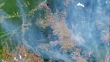
Amazon deforestation, 2000-2012 - 4K 影片檔
Deforestation in the Amazon, 2000-2012. Satellite image sequence of the northwest of the state of Rondonia in Brazil, showing areas of deforestation (light green and brown). Between 1970 and 2000 over 53,300 square kilometres of forest were lost. Since 2000 the rate of loss per year has increased. Deforestation is normally undertaken to create grazing areas for cattle. The removal of trees leaves soil exposed to rapid erosion by water, leading to the removal of valuable top soil. Images taken by the Moderate Resolution Imaging Spectroradiometer (MODIS) on NASA's Terra satellite. See clip K005/6632 for a version with the years labelled with text.




購買授權
所有免版稅授權包含全球使用權限、全面的法律保障,定價簡單並享有計量折扣。
HK$3,500.00
HKD